I
was generally aware of petroleum production in California, both from geology
and films such as The Two Jakes
(1990) and There Will Be Blood (2007). On the other hand, the state’s popular
image, particularly that of southern California, usually brings to mind the
entertainment industry, freeways, traffic, surfing, large-scale agriculture,
among other things, not oil wells and pumps in one’s backyard. However, in
early June, driving north from Los Angeles International Airport (LAX) on La
Cienega Boulevard, just arrived to attend our son’s wedding, we cut through the
Inglewood oil field, in the Blair Hills/Baldwin Hills/ Culver City area. It
seemed more like Texas than Hollywood. Continuing north, La Cienega becomes
Fairfax Avenue, and eventually the western boundary of Hancock Park, which
includes the La Brea Tar Pits (June 19 blog post), over the Salt Lake oil
field.


 |
| Driving by Inglewood oil field, northbound on La Cienega Boulevard, from LAX |
 |
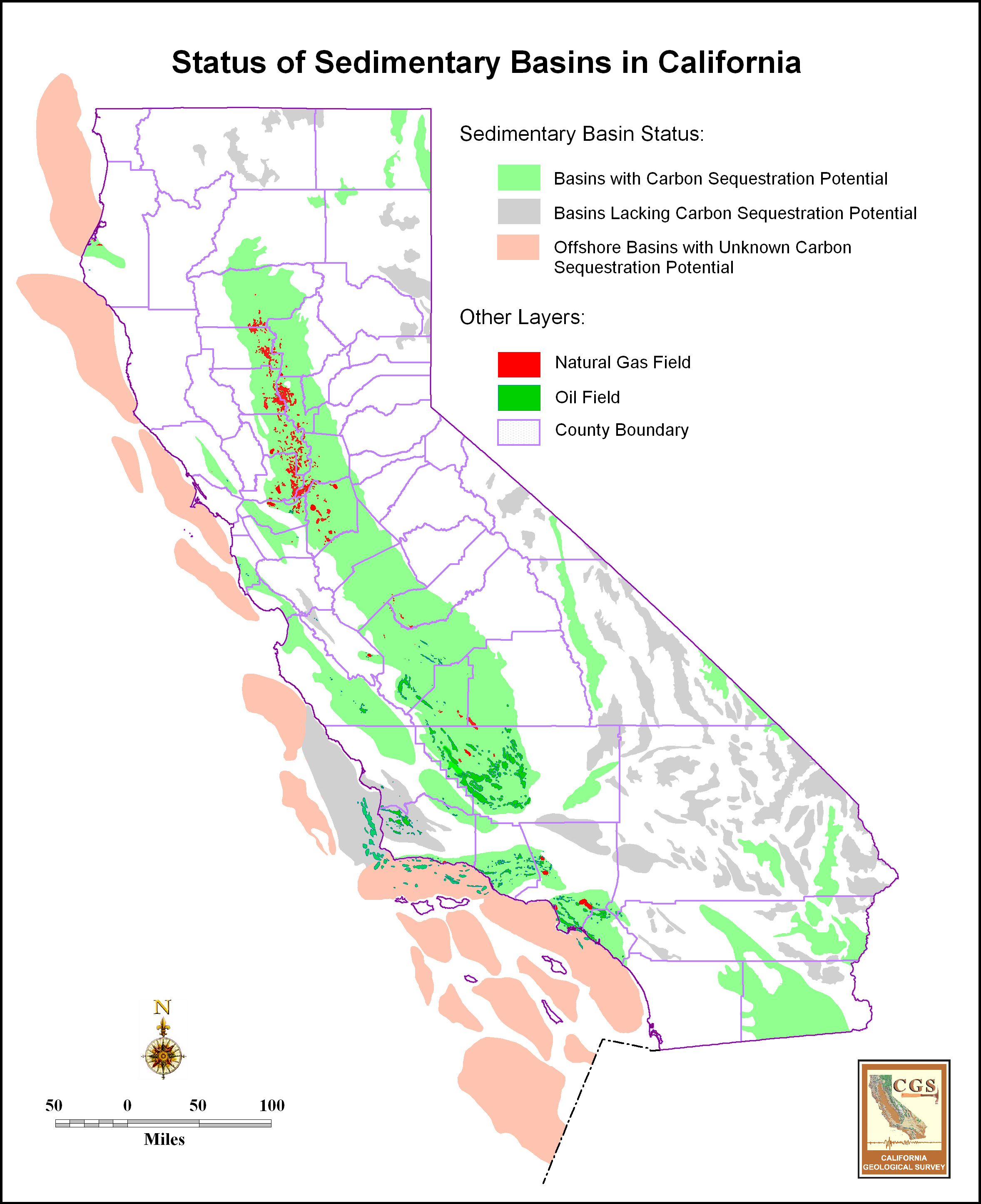
| California sedimentary basin map (California Geological Survey, http://gif.berkeley.edu/westcarb/images/maps/CA_basins_status.jpg) with status of their carbon sequestration potential and known oil and gas fields within them. Los Angeles basin is the southernmost coastal onshore basin (includes oil and gas fields). Just to the north of the LA basin is the Ventura basin. The large basin in central California is the San Joaquin basin, whose oil-rich southern half, centered around Bakersfield, provides ~10% of US domestic crude oil production. |
 |
| Oil fields of the Los Angeles basin (from http://users.humboldt.edu/ogayle/hist383/LosAngeles.html): Salt Lake oil field of La Brea Tar Pits is one of northernmost fields; Inglewood field just to the SE along Newport-Inglewood fault. |
Inglewood
and Salt Lake are two of 68 named oil fields within the Los Angeles basin, the
most prolific petroleum basin in the world on an oil-to-sediment ratio
(Gautier, 2012a, 2012b). The formation of the basin is related to late Neogene
tectonic block reconfiguration along the boundary of the Pacific and North
American plates (Wright, 1991) and is “partially inverted” (Nemčok and others, 2005).
Inverted basins are extensional basins that later experienced compression with
folding and/or reverse fault movement. In the Inglewood oil field, the
NW-SE-trending Newport-Inglewood fault zone cuts an inversion anticline. Such
faulted anticlines form the largest (Gautier, 2012b) and most common (73%;
Wright 1991) traps in the basin. The prime oil source rocks for the Los Angeles
basin oil fields, and other offshore and onshore basins in southern California,
are the organic-rich Miocene Monterey and stratigraphically-equivalent
formations. A geochemical biomarker study of Los Angeles basin oils by Peters
and others (2014) indicates differences in oil type/chemistry among and within fields are
due to variation in organofacies within the Miocene formations (whether oil was
generated from marine algae, land plants or a mixture).
 |
| General tectonic cross-section of Los Angeles basin from https://www.unavco.org/highlights/2001/usgs_la.html. The Newport-Inglewood fault cuts through the Long Beach and Inglewood oil fields, among others. Eastern basin oil fields, such Brea Olinda, lie along the western edge of the Puente Hills (those above the thrust of the same name at the bottom of the diagram). |
 |
| Cross-section of central Inglewood field from SW (left) to NE (right) through faulted anticlinal structure of the Inglewood oil field (Figs. 4-2 and 2-4 in http://www.inglewoodoilfield.com/res/docs/102012study/Hydraulic%20Fracturing%20Study%20Inglewood%20Field10102012.pdf) |
Although drilling
for oil in southern California first started a little earlier, the “Black Gold”
rush began in earnest about 1890. A timeline of petroleum industry development,
along with an economic history outline of southern California, including
agriculture, water, and demographics (good for reviewing before watching Chinatown and The Two Jakes) can be found at http://users.humboldt.edu/ogayle/hist383/LosAngeles.html
(petroleum under Goal #3). Important LA basin discoveries
in the 1920’s helped make California the number one state in US oil production
until the 1930’s. The oil derricks in the background of the 1913 excavation
photo included in my earlier blog post on the La Brea Tar Pits indicate the
intensity of the petroleum industry in those decades. Most discoveries prior to
1925 were based on “oil
seeps and Quaternary topographic uplifts” (Wright, 1991).
The coincident
population growth and urbanization of the Los Angeles region, driven in large
part by opportunities in the petroleum industry, resulted in the most urban oil
basin in world. Vintage photos show “forests” of oil derricks including along
the beaches (http://www.theatlantic.com/photo/2014/08/the-urban-oil-fields-of-los-angeles/100799/;
photos 2 & 3). A great collection of
current and historic photos of petroleum exploitation in the basin (http://clui.org/newsletter/spring-2010/urban-crudeh)
has been compiled by the Center for Land Use Interpretation.
The photographic collection page (http://clui.org/sites/default/files/exhibits/online/index.html)
has tabs for six regions within the Los Angeles basin, including Inglewood; my favorite is “Westside and Downtown” which really shows how production facilities have been disguised
in crowded and manicured residential and business districts. (I will have to
pay more attention when I visit again!) The
photos also point out that the oozing tar and leaking methane are not just a
feature of the Tar Pits, but an issue throughout a region where people work and
live on top of prolific oil fields. This makes it difficult to distinguish
between natural seeps and leaks and those from poor industrial practices (http://www.thedailybeast.com/articles/2014/12/06/the-fiery-underground-oil-pit-eating-l-a.html).


Compared
to the more discrete production platforms in many developed areas of the basin,
the Inglewood oil field is “largest remaining contiguous oil production
landscape in urbanized Los Angeles”
(italics are mine; http://clui.org/sites/default/files/exhibits/online/inglewood.html). The field was first developed in 1924 by Standard Oil of
California. Recent continued Inglewood development and drilling, however, has
been controversial (http://wattway.org/2011/04/inglewood-oil-field-controversy-near-an-end/;
http://thegrio.com/2010/03/15/oil-field-near-black-beverly-hills-may-be-threat-to-residents/).
Just before 2003, due to declining production, adjacent communities had plans to
purchase the land to redevelop as a park. However, in 2003, new operator
Plains Exploration (PXP) discovered large untapped reserves. Drilling surged,
including under residential areas, peaking in 2005-06. There were complaints of
noise and fumes, plus two evacuations in 2006. At that time, a moratorium on new
drilling was imposed by Los Angeles county. In 2008, PXP submitted a plan to
the county for regulating production operations, and drilling resumed. However, late in that year, a
number of lawsuits against the county and PXP were filed, alleging the plan did
not have adequate environmental impact oversight before approval. A settlement
agreement was reached in July 2011 (http://www.inglewoodoilfield.com/res/docs/SettlementAgreementDatedJuly152011.pdf)
which, among other things, stipulates locations of wells of various depths
relative to sensitive areas and annual reporting of such wells; sets noise
restrictions; limits number of drill rigs operating concurrently, number of
wells drilled or redrilled in a year; lowers total new well limit to no more than 500 by
2028; regulates well abandonment; requires health assessment studies and
regular air monitoring; sets parameters for closing field if total production
falls below a certain threshold; and required a study of the impacts of various oil production fracturing
methods by an “independent consultant” paid for by PXP. The fracturing methods
included conventional and high-volume (HVHF) hydraulic fracturing and
high-rate gravel-packing operations. (The resulting report (http://www.inglewoodoilfield.com/res/docs/102012study/Hydraulic%20Fracturing%20Study%20Inglewood%20Field10102012.pdf)
defines conventional hydraulic fracturing as that used on sandstone, dolomite,
or limestone; HVHF is used on shale formations typically requiring more pressure
and fluid volume. Gravel-packing is injection of coarser sand between the well
casing and producing formation to prevent formation sand from flowing into the
well. The “gravel” is not large like pea gravel or river rock, but, on the
Wentworth grain-size scale, typically is fine- to very-coarse sand size, 1/8- 1.5 mm. High-rate gravel packing does create fractures near the well bore.) Although gravel-packing and conventional
hydraulic fracturing are apparently common in Inglewood, the only two HVHF
wells by 2012 were the single-stage tests in two vertical wells as a part of
the fracturing study. The 2012 mandated fracturing
report concluded there were no detectable environmental effects or effects that exceeded regulated limits from the HVHF tests or conventional fracturing and gravel packing operations.
This has been challenged by environmental and community groups (http://baldwinhillsoilwatch.org/fracking-in-baldwin-hills/baldwin-hills-fracking-study/)
who believe that the report has an industry bias, was not properly
reviewed, is geographically restricted, and that the HVHF tests were limited
compared to actual production practices.
The US Geological Survey completed an assessment in 2012 of remaining oil in the Los Angeles basin using the 10 giant (>1 billion barrel) oil fields (http://pubs.usgs.gov/fs/2012/3120/fs2012-3120.pdf), which includes Inglewood. The range of remaining technically recoverable oil is 1.4 billion (high probability) to 5.6 billion (low probability) barrels with a mean of 3.2 billion. For Inglewood alone, the mean remaining recoverable oil is 250 million barrels. The assessment concedes that more recoverable oil is, of course, possible in other smaller known or undiscovered fields in the basin. However, it also concludes that unrestricted recovery of all remaining oil resources is improbable due to "competing land use practice and evolving community priorites" which have been a signature of the basin since modern petroleum exploitation began there.
Cited
references:
Gautier, D.L.,
Tennyson, M.E., Cook, T.A., Charpentier, R.R., and Klett, T.R., 2012a, revised
2013, Remaining recoverable petroleum in ten giant oil fields of the Los
Angeles Basin, southern California: U.S. Geological Survey Fact Sheet
2012–3120, v. 1.1, 2 pages (http://pubs.usgs.gov/fs/2012/3120/fs2012-3120.pdf)
Gautier, D.L.,
Tennyson, M.E., Cook, T.A., Charpentier, R.R., and Klett, T.R., 2012b, Forgone
Oil in the Los Angeles Basin: Assessment of remaining petroleum in giant fields
of Southern California: AAPG Search and Discovery Article #20164 (abstract and
presentation), AAPG Annual Meeting Program, Long Beach, California (http://www.searchanddiscovery.com/pdfz/documents/2012/20164gautier/ndx_gautier.pdf.html).
Nemčok, M.,
Schamel, S., and Gayer, R., 2005, Thrustbelts: Structural architecture, thermal
regimes and petroleum systems: Cambridge University Press, 541 pages.
Peters, K.E., Ramos,
L.S., Zumberge, J.E., Wright, T.L., 2014, Petroleum systems in the world’s most
petroliferous basin, Los Angeles, California: AAPG Search and Discovery Article
#80386 (abstract and presentation), AAPG Annual Meeting Program, Houston, Texas
(http://www.searchanddiscovery.com/documents/2014/80386peters/ndx_peters).
Wright, T.L.,
1991, Structural geology and tectonic evolution of the Los Angeles basin,
California in K.T. Biddle, eds.,
Active Margin Basins, American Association of Petroleum Geologists Memoir 52,
p. 35-79. http://archives.datapages.com/data/specpubs/basinar3/data/a135/a135/0001/0000/0035.htm (abstract)