Monday, September 7, 2015

Onshore oil field fires . . . in film


Just as I was finishing the last blog post on the Inglewood oil field in the Los Angeles basin, with links to historic LA photos of “forests” of derricks, I caught the last 30 minutes of one of my favorite petroleum-themed films, Tulsa (1949), a classic film depiction of the early 20th-century Oklahoma oil boom (http://www.ogs.ou.edu/fossilfuels/pdf/OKOilNotesPDF.pdf


The climax of Tulsa is an oil field fire in a jungle of closely-spaced wooden derricks whose spectacle rivals the burning of Atlanta in Gone with the Wind. Although the New York Times did not give the film a great review (too melodramatic and “cliché-loaded”), it did praise the oil field conflagration as “fiery a Technicolored burn-out as ever you're likely to see”. Not surprisingly, the film was nominated for a 1950 Special Effects Academy Award. Interestingly, I did find that the derrick-field fire was not full-scale but a miniature model set (http://nzpetesmatteshot.blogspot.com/2014/12/magicians-of-miniature.html; in this fascinating, but long, blog post, the Tulsa photos are ~1/3 of the way down, easiest to find by searching on the page for “Tulsa”.)

The conflicts in Tulsa: pollution, land preservation versus development, over-production versus paced extraction, sound surprisingly current, but just emphasize that these issues are perennial and not new. The oil pollution of a creek that runs through an adjacent ranch, sickening and killing cattle, is the trigger that causes the ranch owner, a former oil man, to toss a lit match into the water to test for contamination, the resulting fire climactically spreading upstream to production derricks. In the denouement, it is resolved that fences will keep cattle from contaminated areas and oil field development will practice conservation. The “conservation”, espoused by the movie’s geologist, includes 1) spacing wells to preserve more grassland and 2) controlled flow to maximize life of field and volume of production. (Producing oil too quickly may draw any underlying water in the reservoir up into the more buoyant oil above it or strand pockets of oil far from the well bore.)

Conventional anticlinal oil trap with natural gas over oil over salt water/brine, controlled by buoyancy and immiscibility (Figure source-http://www.tulane.edu/~sanelson/eens1110/energy.htm).

Tulsa, of course, is not the only movie that illustrates competing land use issues in the lower Plains states. Such conflict, reminiscent of that in the Los Angeles basin (business/residential development vs. oil fields), has me humming “The farmer and the cow man should be friends” from the musical/movie, Oklahoma. And, of course, the cattle vs. oil issues resurface in the television prime-time soap, Dallas (1978-1991), and James Dean’s last film, Giant (1956).

Two other classic black-and-white films with distinguished natural disaster special effects, IMHO, are San Francisco (1936), in which the tragedy of the 1906 earthquake helps the leading characters realize their true love for each other, and The Hurricane (1937) with a culminating South Pacific typhoon. Neither film was nominated for a Special Effects Academy Award, but both won for Sound (Recording).

However, while mentioning a few of the best and most spectacular disaster effects in classic movies, I might as well mention one of the worst, Beginning of the End (1957): giant grasshoppers, which grew after eating experimental radioactivity-treated wheat, migrate to the city of Chicago, devouring people along the way. I may have only seen the last half of this movie a long time ago, but grasshoppers crawling on an obvious photo of the Wrigley Building, including defying gravity and walking off into the blue sky, was jaw-droppingly memorable (“Inconceivable!” to quote The Princess Bride). That this conspicuous budgetary short-cut in special effects is also described in the Wikipedia entry on the film indicates it was apparent to numerous viewers! 
From Beginning of the End (1957)

Friday, August 7, 2015

Los Angeles Basin: Most prolific and most urban petroleum province in the world


I was generally aware of petroleum production in California, both from geology and films such as The Two Jakes (1990) and There Will Be Blood (2007). On the other hand, the state’s popular image, particularly that of southern California, usually brings to mind the entertainment industry, freeways, traffic, surfing, large-scale agriculture, among other things, not oil wells and pumps in one’s backyard. However, in early June, driving north from Los Angeles International Airport (LAX) on La Cienega Boulevard, just arrived to attend our son’s wedding, we cut through the Inglewood oil field, in the Blair Hills/Baldwin Hills/ Culver City area. It seemed more like Texas than Hollywood. Continuing north, La Cienega becomes Fairfax Avenue, and eventually the western boundary of Hancock Park, which includes the La Brea Tar Pits (June 19 blog post), over the Salt Lake oil field.

Driving by Inglewood oil field, northbound on La Cienega Boulevard, from LAX
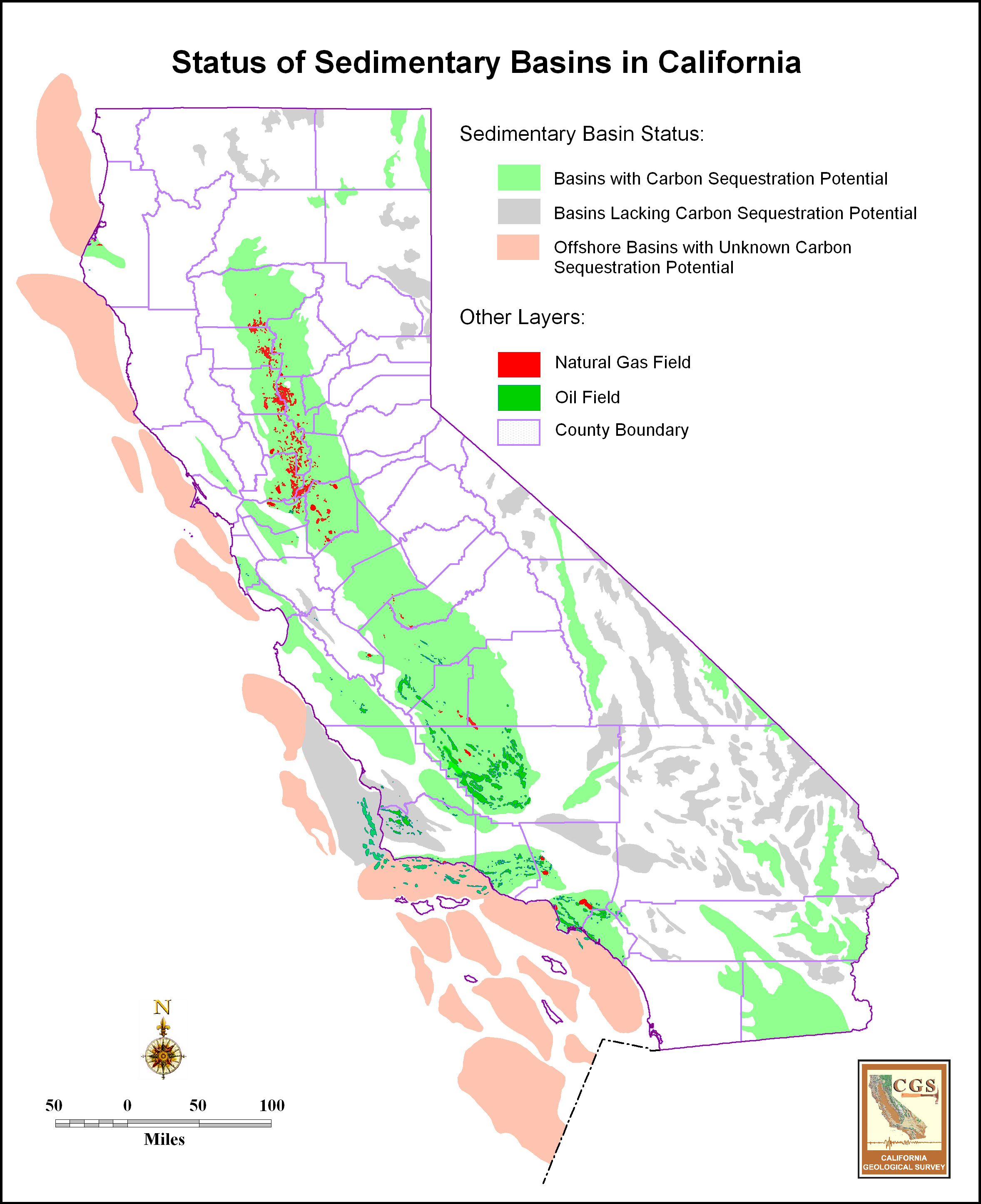
California sedimentary basin map (California Geological Survey, http://gif.berkeley.edu/westcarb/images/maps/CA_basins_status.jpg) with status of their carbon sequestration potential and known oil and gas fields within them. Los Angeles basin is the southernmost coastal onshore basin (includes oil and gas fields). Just to the north of the LA basin is the Ventura basin. The large basin in central California is the San Joaquin basin, whose oil-rich southern half, centered around Bakersfield, provides ~10% of US domestic crude oil production.
Oil fields of the Los Angeles basin (from http://users.humboldt.edu/ogayle/hist383/LosAngeles.html): Salt Lake oil field of La Brea Tar Pits is one of northernmost fields; Inglewood field just to the SE along Newport-Inglewood fault.

Inglewood and Salt Lake are two of 68 named oil fields within the Los Angeles basin, the most prolific petroleum basin in the world on an oil-to-sediment ratio (Gautier, 2012a, 2012b). The formation of the basin is related to late Neogene tectonic block reconfiguration along the boundary of the Pacific and North American plates (Wright, 1991) and is “partially inverted” (Nemčok and others, 2005). Inverted basins are extensional basins that later experienced compression with folding and/or reverse fault movement. In the Inglewood oil field, the NW-SE-trending Newport-Inglewood fault zone cuts an inversion anticline. Such faulted anticlines form the largest (Gautier, 2012b) and most common (73%; Wright 1991) traps in the basin. The prime oil source rocks for the Los Angeles basin oil fields, and other offshore and onshore basins in southern California, are the organic-rich Miocene Monterey and stratigraphically-equivalent formations. A geochemical biomarker study of Los Angeles basin oils by Peters and others (2014) indicates differences in oil type/chemistry among and within fields are due to variation in organofacies within the Miocene formations (whether oil was generated from marine algae, land plants or a mixture).
General tectonic cross-section of Los Angeles basin from https://www.unavco.org/highlights/2001/usgs_la.html. The Newport-Inglewood fault cuts through the Long Beach and Inglewood oil fields, among others. Eastern basin oil fields, such Brea Olinda, lie along the western edge of the Puente Hills (those above the thrust of the same name at the bottom of the diagram).
Cross-section of central Inglewood field from SW (left) to NE (right) through faulted anticlinal structure of the Inglewood oil field (Figs. 4-2 and 2-4 in http://www.inglewoodoilfield.com/res/docs/102012study/Hydraulic%20Fracturing%20Study%20Inglewood%20Field10102012.pdf)

Although drilling for oil in southern California first started a little earlier, the “Black Gold” rush began in earnest about 1890. A timeline of petroleum industry development, along with an economic history outline of southern California, including agriculture, water, and demographics (good for reviewing before watching Chinatown and The Two Jakes) can be found at http://users.humboldt.edu/ogayle/hist383/LosAngeles.html (petroleum under Goal #3). Important LA basin discoveries in the 1920’s helped make California the number one state in US oil production until the 1930’s. The oil derricks in the background of the 1913 excavation photo included in my earlier blog post on the La Brea Tar Pits indicate the intensity of the petroleum industry in those decades. Most discoveries prior to 1925 were based on “oil seeps and Quaternary topographic uplifts” (Wright, 1991).

The coincident population growth and urbanization of the Los Angeles region, driven in large part by opportunities in the petroleum industry, resulted in the most urban oil basin in world. Vintage photos show “forests” of oil derricks including along the beaches (http://www.theatlantic.com/photo/2014/08/the-urban-oil-fields-of-los-angeles/100799/; photos 2 & 3). A great collection of current and historic photos of petroleum exploitation in the basin (http://clui.org/newsletter/spring-2010/urban-crudeh) has been compiled by the Center for Land Use Interpretation. The photographic collection page (http://clui.org/sites/default/files/exhibits/online/index.html) has tabs for six regions within the Los Angeles basin, including Inglewood; my favorite is “Westside and Downtown which really shows how production facilities have been disguised in crowded and manicured residential and business districts. (I will have to pay more attention when I visit again!) The photos also point out that the oozing tar and leaking methane are not just a feature of the Tar Pits, but an issue throughout a region where people work and live on top of prolific oil fields. This makes it difficult to distinguish between natural seeps and leaks and those from poor industrial practices (http://www.thedailybeast.com/articles/2014/12/06/the-fiery-underground-oil-pit-eating-l-a.html).

iPhone screen snaps of Inglewood oil field (brown area next to red pin at Kenneth Hahn Park adjacent to oil field) within 1) greater Los Angeles area (top; note purple LAX airport to SW; the very green spot just below the "i" in Beverly Hills is the La Brea Tar Pits), and 2) close-up (bottom). Mid-afternoon traffic (red & orange dashes/dots) included to highlight highways.


Compared to the more discrete production platforms in many developed areas of the basin, the Inglewood oil field is “largest remaining contiguous oil production landscape in urbanized Los Angeles” (italics are mine; http://clui.org/sites/default/files/exhibits/online/inglewood.html). The field was first developed in 1924 by Standard Oil of California. Recent continued Inglewood development and drilling, however, has been controversial (http://wattway.org/2011/04/inglewood-oil-field-controversy-near-an-end/; http://thegrio.com/2010/03/15/oil-field-near-black-beverly-hills-may-be-threat-to-residents/). Just before 2003, due to declining production, adjacent communities had plans to purchase the land to redevelop as a park. However, in 2003, new operator Plains Exploration (PXP) discovered large untapped reserves. Drilling surged, including under residential areas, peaking in 2005-06. There were complaints of noise and fumes, plus two evacuations in 2006. At that time, a moratorium on new drilling was imposed by Los Angeles county. In 2008, PXP submitted a plan to the county for regulating production operations, and drilling resumed. However, late in that year, a number of lawsuits against the county and PXP were filed, alleging the plan did not have adequate environmental impact oversight before approval. A settlement agreement was reached in July 2011 (http://www.inglewoodoilfield.com/res/docs/SettlementAgreementDatedJuly152011.pdf) which, among other things, stipulates locations of wells of various depths relative to sensitive areas and annual reporting of such wells; sets noise restrictions; limits number of drill rigs operating concurrently, number of wells drilled or redrilled in a year; lowers total new well limit to no more than 500 by 2028; regulates well abandonment; requires health assessment studies and regular air monitoring; sets parameters for closing field if total production falls below a certain threshold; and required a study of the impacts of various oil production fracturing methods by an “independent consultant” paid for by PXP. The fracturing methods included conventional and high-volume (HVHF) hydraulic fracturing and high-rate gravel-packing operations. (The resulting report (http://www.inglewoodoilfield.com/res/docs/102012study/Hydraulic%20Fracturing%20Study%20Inglewood%20Field10102012.pdf) defines conventional hydraulic fracturing as that used on sandstone, dolomite, or limestone; HVHF is used on shale formations typically requiring more pressure and fluid volume. Gravel-packing is injection of coarser sand between the well casing and producing formation to prevent formation sand from flowing into the well. The “gravel” is not large like pea gravel or river rock, but, on the Wentworth grain-size scale, typically is fine- to very-coarse sand size, 1/8- 1.5 mm. High-rate gravel packing does create fractures near the well bore.)  Although gravel-packing and conventional hydraulic fracturing are apparently common in Inglewood, the only two HVHF wells by 2012 were the single-stage tests in two vertical wells as a part of the fracturing study. The 2012 mandated fracturing report concluded there were no detectable environmental effects or effects that exceeded regulated limits from the HVHF tests or conventional fracturing and gravel packing operations.  This has been challenged by environmental and community groups (http://baldwinhillsoilwatch.org/fracking-in-baldwin-hills/baldwin-hills-fracking-study/) who believe that the report has an industry bias, was not properly reviewed, is geographically restricted, and that the HVHF tests were limited compared to actual production practices.

The US Geological Survey completed an assessment in 2012 of remaining oil in the Los Angeles basin using the 10 giant (>1 billion barrel) oil fields (http://pubs.usgs.gov/fs/2012/3120/fs2012-3120.pdf), which includes Inglewood. The range of remaining technically recoverable oil is 1.4 billion (high probability) to 5.6 billion (low probability) barrels with a mean of 3.2 billion.  For Inglewood alone, the mean remaining recoverable oil is 250 million barrels. The assessment concedes that more recoverable oil is, of course, possible in other smaller known or undiscovered fields in the basin. However, it also concludes that unrestricted recovery of all remaining oil resources is improbable due to "competing land use practice and evolving community priorites" which have been a signature of the basin since modern petroleum exploitation began there.

Cited references:

Gautier, D.L., Tennyson, M.E., Cook, T.A., Charpentier, R.R., and Klett, T.R., 2012a, revised 2013, Remaining recoverable petroleum in ten giant oil fields of the Los Angeles Basin, southern California: U.S. Geological Survey Fact Sheet 2012–3120, v. 1.1, 2 pages (http://pubs.usgs.gov/fs/2012/3120/fs2012-3120.pdf)

Gautier, D.L., Tennyson, M.E., Cook, T.A., Charpentier, R.R., and Klett, T.R., 2012b, Forgone Oil in the Los Angeles Basin: Assessment of remaining petroleum in giant fields of Southern California: AAPG Search and Discovery Article #20164 (abstract and presentation), AAPG Annual Meeting Program, Long Beach, California (http://www.searchanddiscovery.com/pdfz/documents/2012/20164gautier/ndx_gautier.pdf.html).

Nemčok, M., Schamel, S., and Gayer, R., 2005, Thrustbelts: Structural architecture, thermal regimes and petroleum systems: Cambridge University Press, 541 pages.

Peters, K.E., Ramos, L.S., Zumberge, J.E., Wright, T.L., 2014, Petroleum systems in the world’s most petroliferous basin, Los Angeles, California: AAPG Search and Discovery Article #80386 (abstract and presentation), AAPG Annual Meeting Program, Houston, Texas (http://www.searchanddiscovery.com/documents/2014/80386peters/ndx_peters).

Wright, T.L., 1991, Structural geology and tectonic evolution of the Los Angeles basin, California in K.T. Biddle, eds., Active Margin Basins, American Association of Petroleum Geologists Memoir 52, p. 35-79. http://archives.datapages.com/data/specpubs/basinar3/data/a135/a135/0001/0000/0035.htm (abstract)

Friday, July 3, 2015

LEGO STEM women


I admit I am a little late to the table (lab table?) only just discovering the August 2014 LEGO Research Institute and its women scientists: astronomer, chemist, and paleontologist. I heard about it a couple weeks ago, possibly through the #distractinglysexy Twitter feed in response to Nobel Laureate Sir Tim Hunt’s comments about “girl” scientists crying in the lab and making male lab workers fall in love with them (http://www.bbc.com/news/blogs-trending-33099289; http://www.ucl.ac.uk/news/news-articles/0615/100615-tim-hunt).

LEGO Research Institute

Coincidently, right after receiving the Research Institute last week through Amazon (sold out through LEGO), I was going through a pile (big pile) of unread Eos newspapers, the weekly, now biweekly and online (Eos.org), newspaper of the American Geophysical Union (agu.org), and found a September 2014 article about the Dutch geoscientist, Ellen Kooijman, who designed the Research Institute set (https://eos.org/articles/lego-set-features-women-scientists). Kooijman and others had observed that few female LEGO people came in adventure or career settings. Scientific American had a blog post just two weeks ago about the evolution of STEM professional LEGO women since the first minifigure in 2013 (http://blogs.scientificamerican.com/voices/lego-adds-more-women-in-science-to-its-lineup/).

Designing LEGO sets in her spare time under the pseudonym, Alatariel, Kooijman works through LEGO Ideas (https://ideas.lego.com/), a LEGO site for fans to propose new sets. If proposals gather 10,000 votes, they are reviewed by LEGO for possible production. Kooijman describes the evolution of the Research Institute also in her blog post at http://alatarielatelier.blogspot.se/p/female-minifigure-set.html?zx=7fc735e0789785ac and an interview at http://jaysbrickblog.com/2014/09/14/interview-ellen-kooijman-designer-lego-research-institute/.

Kooijman’s next set to hit stores, on August 1, is the Big Bang Theory, based on the popular television show, and set in Sheldon and Leonard’s apartment (https://ideas.lego.com/projects/58456). “Science Adventures” (https://ideas.lego.com/projects/83039) is another proposed LEGO set by Kooijman that is in review, having reached 10,000 votes in less than two months. This set includes an archeologist, wildlife biologist with tiger, and a field geologist with outcrop, hammer, geologic map, and Brunton compass.

“Research geology” (https://ideas.lego.com/projects/93813) is a proposed set by another designer that still needs about 6600 votes to reach LEGO review. It has two vignettes 1) an outcrop with male and female geologists and a dog: “there's always the obligatory geology dog” (been there, done that, love that!), and 2) a microscope lab setting with SEM and light microscope (I can fantasize or play that the petrographic microscope is reflected light, like that used in organic petrology since one needs reflected light to also check polished SEM mounts).

Some STEM professionals, including women, appear in the LEGO Minifigure sets (http://blogs.scientificamerican.com/guest-blog/breaking-brick-stereotypes-lego-unveils-a-female-scientist/). I also bought another separate woman paleontologist minifigure (Collectible Minifigures Series 13) because she is wearing field gear, and, without her dinosaur bone and ammonite, can double as any field geologist before the “Science Adventures” set is released.  I used her for “scale” today in my #FridayFold tweet!


 Now to put together that Lego Research Institute dino skeleton. . .

Saturday, June 20, 2015

Coal and organic petrology bibliographic and information resources


            Back in 2002 at the annual AAPG (American Association of Petroleum Geologists) meeting in Houston, I hosted an exhibit booth for The Society for Organic Petrology (TSOP). It surprised me that not once, but at least twice, graduate students came up to me and said how much they appreciated the TSOP online bibliography of coal/organic petrology, geology, utilization articles. The students were from schools with limited organic petrology programs or library resources and found the TSOP bibliography invaluable.

            So, as we get into the summer when many graduate students or junior-senior undergraduate students may be concentrating on research rather than classes, here are some organic petrology resources.

Online bibliography:

TSOP reference page at http://tsop.org/references.html lists multiple topics: click on topics to download associated Microsoft Word documents (.docx). Last checked June 2024, many updated in 2021.

Online photomicrograph atlases:

US Geological Survey Organic Petrology Photomicrograph Atlas: http://energy.usgs.gov/Coal/OrganicPetrology/PhotomicrographAtlas.aspx (Lots of photos of macerals in coal and those in oil and gas shales.)

Crelling’s Petrographic Atlas of Coals and Carbons: http://www.coalandcarbonatlas.siu.edu/ (includes flyash and chars, cokes)

Indiana Geological Survey Atlas of Coal Macerals: http://igs.indiana.edu/Coal/Macerals.cfm

Books:

Available in various formats: Hardcover, paperback, or e-book. This list is not comprehensive, but include classics or my favorites.

Organic Petrology by Taylor, G.H., Teichmüller, M., Davis, A., Diessel, C.F.K., Littke, R., Robert, P., 1998: Gebrüder Borntraeger, Berlin, 704 pages. (This is the successor to Stach’s Textbook of Coal Petrology, 1982, 3rd ed., by Stach, E., Mackowsky, M.-Th., Teichmüller,  M., Taylor, G.H., Chandra, D., Teichmüller, R., Murchison, D.G., and Zierke, F., eds., Gebruder Borntraeger, Berlin, 535 p.)

Petroleum Formation and Occurrence (2nd. ed.) by B.P. Tissot and D.H. Welte, 1984, Springer Verlag, Berlin, 699 pages. Not organic petrology, but much on kerogen chemical evolution in the formation of petroleum.

Sedimentary organic matter by Richard V. Tyson, 1995, Chapman & Hall, London, 615 pages. Excellent comprehensive book on particulate organic matter with beautiful photos.

A Petrographic Atlas of Canadian Coal Macerals and Dispersed Organic Matter  by Judith Potter, Lavern Stasiuk, and Alexander Cameron (eds.) (http://www.cscop.org/atlas.php, available from Geological Survey of Canada, Calgary; now available on CD).

Coal-bearing Depositional Systems by Claus F. K. Diessel, 1992, Springer Verlag, 721 pages.

Coal Geology  by Larry Thomas, 2012 (2nd ed.), Wiley-Blackwell, 454 pages. This includes coal origin and petrology, but also exploration, mining, utilization, and environmental issues.

Applied Coal Petrology: The role of petrology in coal utilization by Isabel Suárez-Ruiz and John Crelling, 2008, Elsevier, 388 pages. Petrographic characterization for predicting behavior in various industrial processes like coke-making (steel industry), combustion, carbonization.

Professional scientific societies or society divisions whose activities concentrate on or include organic petrology (=petrography and geochemistry of coal and sedimentary organic matter including petroleum source rocks). TSOP, AAPG, GSA offer student research grant opportunities:

The Society for Organic Petrology (TSOP; www.tsop.org; besides the references page, there is a webpage with good links to other organic petrology-related sites: http://www.tsop.org/links/index.htm)

The International Committee on Coal and Organic Petrology (ICCP; www.iccop.org; this society is the governing organization for coal petrology terminology and organic petrographer accreditation)

The Canadian Society for Coal Science and Organic Petrology (http://www.cscop.org/)

Energy Geology Division, Geological Society of America (formerly the Coal Geology Division) (http://www.uky.edu/KGS/coal/GSA/; besides the general GSA student research grant programs, this division administers two specific research grants)

Energy Minerals Division (AAPG) (http://emd.aapg.org/; does include uranium)

Friday, June 19, 2015

The La Brea Tar Pits, with some igneous notes thrown in!


Two weeks ago my title was MOG: “Mother-of-the-Groom” in US wedding lingo. I was in Los Angeles, California, to celebrate the wedding of my son, whose apartment is just a couple blocks from the world-famous La Brea Tar Pits.


On the 1-mile walk from our hotel to son’s apartment, I cut through Hancock Park, which includes the campus of LACMA (Los Angeles County Museum of Art) and the Tar Pits. I walked under Levitated Mass, a large outdoor static-art piece (nod to any igneous geologists out there), opened to the public in 2012*, and then ESE through the grounds of the adjacent Tar Pits.
Levitated Mass in upper left corner, LACMA left and lower center, Tar Pits is green space. The large Lake Pit, with mammoth sculpture group, just to left of red pin; Project 23 boxes and exam space are little white dots in upper center (iPhone screen capture from Maps app).

Levitated Mass by Michael Heizer. Top photo from LACMA website; bottom photo, and all others with no attribution in this blog post, by Malinconico. The art piece includes the rock mass, walkway, and surrounding decomposed granite aggregate. The big rock is a diorite, probably Cretaceous, from Stone Valley Quarry, an aggregate quarry in the Jurupa Mountains near Glen Avon, California*.
Yes, people will tell you that the name, La Brea Tar Pits, is a redundancy since La Brea means “tar” in Spanish. Rancho La Brea was one of the original colonial Spanish land grants (http://www.tarpits.org/la-brea-tar-pits/timeline: History). Oil seeps upward from the Salt Lake oil field, in the northern part of the Los Angeles basin (http://www.searchanddiscovery.com/pdfz/documents/2012/20164gautier/ndx_gautier.pdf.html, slide 6; http://www.ucmp.berkeley.edu/quaternary/labrea.php), and the loss of volatile hydrocarbons leaves behind a tarry “gooey” residue AKA asphalt or bitumen.


Native Americans and later European settlers had used the tar for mortar, glue, caulking, medicine, and fuel. These uses were also known 5000 years ago in the Middle East (Daniel Yergin, The Prize, 1991, p. 23-24). The Hancock family, who owned Rancho La Brea in the late 19th/early 20th centuries, initially mined the asphalt, but later went into oil production on the land. Animal bones found in the La Brea tar were originally thought to be those of modern cattle, but, in 1875, it was recognized that the bones were actually fossils. Studies since have been “the core of late Pleistocene North American [paleontological] research”.
 
Excavating fossils 1913-15 at La Brea, Hancock Ranch, with oil wells in background (http://www.tarpits.org/la-brea-tar-pits/timeline: Excavations).
The present-day La Brea ponds filled with water and a scum of tar are remnants of former fossil (numbered on map) or mined-asphalt (Lake Pit) excavation pits (http://www.tarpits.org/visit/map). Besides these pits, a large number of tar-encased fossils are currently being “released” from Project 23: in 2006, during construction of an underground parking garage for LACMA, new fossil deposits were found. Twenty-three (therefore the name, Project 23) large wooden boxes were built around the masses of asphalt, to preserve the relationship of bones to each other, and removed, along with over 300 buckets of asphalt, for further examination. One can see remaining boxes outside on the grounds (photos below) with preliminary examination workstations and a blackboard describing the latest in what’s been found. Fossil exhibits, laboratories and research facilities are in the Page Museum onsite.
 
Pit 13
Tarry scum on surface of water in Lake Pit
Project 23 preliminary examination lab: Large wooden box, by blue wheelbarrow, is open, tent behind holds exam table space, other large boxes in background.
The fossils found at La Brea represent those from ~40,000 years ago (Late Pleistocene) into the Quaternary (<11,700 years ago). Quaternary fauna recovered are like those we live with today, but the Late Pleistocene fossils include large extinct mammals such as mastodons, mammoths, and the saber-toothed cats (http://www.tarpits.org/la-brea-tar-pits/timeline: Pleistocene). Most of the recovered fossils are those of predators and scavengers, assumably packs of predators chasing lone prey, all getting stuck in the tar (http://www.ucmp.berkeley.edu/quaternary/labrea.php). Several causes of the extinction at the end of the Pleistocene have been hypothesized. Climate change at the end of the last (Wisconsin) Ice Age, overkill by early man, or a combination of both are suggested. A very controversial hypothesis was climate change caused by impact or low-atmosphere explosion of a meteor over Canada (http://www.nature.com/news/evidence-found-for-planet-cooling-asteroid-1.13661 plus references for and against cited in linked PNAS paper and weblinks. I was never convinced of such an impact, and a 2023 open-access article in Earth-Science Reviews refutes that hypothesis.


I exited the Tar Pits by the large Lake Pit and its sculpture group of three Columbian mammoths: the mother tragically mired in tar, with panicked offspring and mate on the shore. The sorrowful scenario, although not fine art, is one of my three personal favorite emotive sculptures, the other two being The Dying Gaul  and The Peace Monument, with Grief leaning on the shoulder of History. 
Lake Pit with mammoth family and bubbling methane in foreground and to left behind mired mother. Page Museum is building in background
After the wedding, we drove to Las Vegas. On the north side of highway I-15 right before the California-Nevada state line are the Mountain Pass rare-earth-element (REE) mine and processing plant**. (At the time of this 2015 trip, Mountain Pass was owned by Molycorp, but the operation went bankrupt and was sold in 2017 [http://www.mining.com/mountain-pass-sells-20-5-million/]).The north rim of the open pit can be seen from the highway. The ore body is the Sulphide Queen stock, a 1.4 billion-year-old carbonatite (note a second igneous reference in this post!). Carbonatite is an igneous rock with a large percent of carbonate minerals (so not the organic carbon of this blog’s focus), which at Mountain Pass are primarily calcite, dolomite, and barite. The REE-bearing ore mineral is bastnäsite. Uses for REE include high-efficiency magnets in modern wind turbines and electric motors, and as coatings in compact fluorescent light bulbs, all important technologies in both saving energy and the transition to non-fossil fuel-based energy systems.

*Some Levitated Mass links about the sculpture, rock source and transport:
** Links to information on Mountain Pass REE deposit:
Mine and processing plant (when owned by Molycorp):
Geology:

Saturday, May 16, 2015

"The black blood of the machine age": Environmental impact of oil spills from ships sunk during the Battle of the Atlantic, offshore US, 1942


Last week, Friday, May 8, was the 70th anniversary of the end of World War II in Europe (Victory in Europe or VE day). The eastern US Atlantic States were spared direct attack, but offshore, shipping, primarily merchant shipping, was targeted heavily by German U-boats from January to August 1942. The quote in the blogpost title vividly refers to petroleum and comes from the documentary Victory at Sea (1952), Episode 3: "Sealing the Breach", which describes the German Atlantic submarine campaign in the first months following the United States’ entry into the war. The high US losses were due to ships traveling alone, nighttime glow from coastal cities silhouetting ship outlines, and lack of adequate Coast Guard and Navy ships and planes for defense against submarines. 

Once armed convoys were instituted for east coast shipping, losses decreased, but 350-400 ships had been sunk (sources vary on number). German U-boats then concentrated on shipping in the Gulf of Mexico (GoM) and the Caribbean. In the GoM, tankers carrying oil from Texas and Louisiana (Victory at Sea) and from refineries in Curacao and Aruba (MIT report cited below) were primary targets. Once armed convoys began there in late 1943, attacks also decreased.

My mother (born 1928) spent parts of many youthful summers in Point Pleasant Beach (PPB), New Jersey, an Atlantic coastal town with a great long white sand beach and boardwalk where her own mother's family had lived for generations. (PPB is about 18 miles from the former Naval Air Station at Lakehurst where the hydrogen-fueled German Zeppelin Hindenburg exploded and burned in May 1937: relatives remembered everyone standing outside to watch the Hindenberg fly over, then several minutes later hearing the fire sirens from many local communities. Blimps from Lakehurst did accompany WWII convoys along coastal New Jersey and New York: Sealing the Breach, minute 10:45.) My mother had mentioned that during World War II, oil and tar was seen on the beach from destroyed ships. Fifteen years later, we spent the entire 1957 summer living in PPB and made daily morning expeditions to the beach. I don't remember any tar balls, only occasional mass strandings of clear jelly fish at low tide, and continuing blimp surveillance  looking this time for Russian subs, but then I was only six. 

What was the immediate impact, and any lasting effects, of oil spills from tankers and ships torpedoed offshore New Jersey during WWII? I found an excellent 1977 report called Impact of Oil Spillage from World War II Tanker Sinkings by the Massachusetts Institute of Technology (MIT) Sea Grant Program. Motivated by then-recent tanker spills, such as the Argo Merchant, December 1976, the researchers focused on two US east coast locations: one main site, Cape Hatteras, North Carolina, because of the large number of nearby offshore sinkings, and one auxiliary site, Asbury Park, NJ, ten miles north of Point Pleasant Beach. The MIT team compiled data from historical records and archives, newspaper and magazine articles, and interviews with coastal residents and shipwreck survivors. They focused on tanker sinkings, which were 70% of US east coast attacks in 1942.

Here are volumes of oil from the report along with other spill volumes for comparison (Exxon Valdez, Argo Merchant, Torrey Canyon from Wikipedia; Deepwater Horizon, various sources including Federal reports; volumes originally given as metric tons or gallons were converted using http://www.cmegroup.com/tools-information/calc_crude.html):
  • US Atlantic coast sinkings, first half 1942: 3.55 million barrels (1/4 of this off Cape Hatteras)
  • Offshore central New Jersey, first half 1942, based on reported volumes of three torpedoed tankers: 264,000 barrels
  • Argo Merchant, tanker (1976): 183,333 barrels
  • Exxon Valdez, tanker (1989): 260,000 barrels spilled (commonly accepted number; was carrying 1.31 million barrels)
  • Torrey Canyon, tanker (UK; 1967): 762,000 barrels
  • Deepwater Horizon platform/well (2010): 4.9 million barrels 
The MIT researchers found there was little oil seen ashore in North Carolina north of Hatteras, but considerable amounts were on beaches to the south around Ocracoke Island, NC. However, there were no reliable reports of any severe or lasting damage to animal populations or habitats. The barrier islands of the North Carolina Outer Banks were true barriers protecting the rich fauna and flora of Pamlico Sound inside to the west. There were minor reports of oiled birds, but were no colloquial reports of offshore fish decreases; commercial fishery records were not available for 1940-45.

The second site examined by the MIT group was the Asbury Park, NJ, area. One of the reasons for this site choice was newspaper and magazine coverage of oil on the beaches, which were, and still are, a major tourist attraction and source of local income. The oil cleanup at Belmar, a beach town between Asbury Park and Point Pleasant Beach, was documented by a Life magazine photographer. The solution to clear oil from the beach surface sand was to fill long ten-foot-deep trenches, dug into the sand, with five feet of the oily sand before covering and burying with clean sand. There was concern that storms would exhume the oil, and variable reports on whether that happened. Like North Carolina, while oiled birds were reported, there was not any recognized effect on fish or bird population numbers.
Tar and oil from torpedoed US tankers on beach at Belmar, NJ, June 1942 
(all photos by Marie Hansen, Time-Life Picture Agency)


Oily sand at Belmar, NJ, June 1942


Ten-foot-deep trenches, on the beach, for burying oily sand at Belmar, NJ, June 1942


The MIT report concluded, that despite uncertainties due to limited data, “regional wildlife and economy survived with minimal difficulty”. The only remediation documented, besides the burning oil at time of attack, was the cosmetic New Jersey coastal beach clean-up.

That there was apparent minimal impact from WWII shipwrecked petroleum is surprising, compared to what we have more recently witnessed from the Deepwater Horizon spill. Major differences in those two events are, in my opinion:
1) Volume of released petroleum;
2) DwH leakage was continuous compared to more sporadic or intermittent torpedoing of ships;
3) Most of shipwreck leakage (point of entry into ocean) was assumably at or close to the surface, whereas, DwH was essentially all at the seafloor;

However, environmental threat from WWII shipwrecks is not past. (Reminder in reference to April 14 post on the Titanic: that ship only used coal, and Palmer and others’ 2003 report referenced there found little geochemical impact from coal on the seafloor.) In 2011, the Baltimore Sun reported that NOAA (National Oceanic and Atmospheric Administration) was "taking an inventory of more than 30,000 coastal shipwrecks — some of them casualties of the 1942 Battle of the Atlantic — and identifying those that pose the most significant threat". The subsequent report by the NOAA National Marine Sanctuaries office was completed in 2013 and submitted to the US Coast Guard. The assessment examined fuel type (oil, coal, wind/sail), salvage engineering and environmental risk assessment with historical and archeological data. The report concluded that 36 wrecks in US waters pose a "worst case discharge" threat from potential oil leakage, recommending 17 for further assessment. Seven of those are on the east coast from North Carolina to Massachusetts. Two more are off the east coast of Florida, five in the GoM, and the remaining three are along the US Pacific coast.

Some of the shipwrecks assessed may be eligible for the National Register of Historic Places, and many are gravesites. The most famous leaking WWII vessel is, of course, the USS Arizona sunk in Pearl Harbor, Hawaii, December 7, 1941. The rainbow oil sheen, the "black blood", always present is one somber reminder that the ship is also a tomb.